- World ::
- North America ::
- Quebec
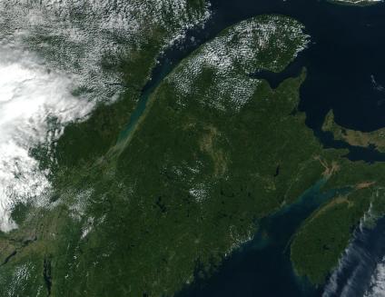
Satellite Image, Photo of Gaspésie and Eastern Quebec
See full-size image (711KB).
Credit: Jacques Descloitres, MODIS Land Rapid Response Team at NASA Goddard Space Flight Center
Gaspésie's Summer end Colors, Quebec. See the same region on September 12, 2001 and October 9, 2001. During the fall, the leaves of deciduous trees change color and then fall off in preparation for the winter season. In early autumn, when the season's first cold temperatures arrive, the forest canopy throughout Eastern Quebec and the Gaspésie region transforms into a kaleidoscope of colors--rich hues of yellows, reds, oranges and browns. These two images were collected by the Moderate-resolution Imaging Spectroradiometer (MODIS), flying aboard NASA's Terra satellite. The two images shows the region of North America spanning from Quebec (upper left) and New Brunswick (upper right) down through the states of Maine, Vermont. MODIS acquired the October 9, 2001 image, after the autumn change in foliage began. The September 12, 2001 image, just before the trees began to change color. Temperate deciduous forests experience different seasons. Their leaves change color and fall off in autumn and winter, and grow back in the spring to serve as the forests' mechanism for absorbing sunlight and carbon dioxide (for photosynthesis) throughout the spring and summer. This adaptation allows plants to survive cold winters.
